


MapTiler Mobile
MapTiler Mobile açıklaması
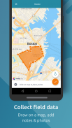
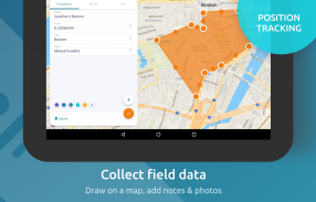
See your GPS position on your own maps. Draw points, polygons and lines on the maps. Collect field data and notes related to a location, attach a photo and fill custom properties.
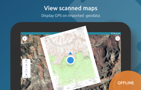
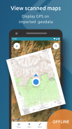
Display offline maps generated with MapTiler (https://www.maptiler.com).
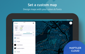
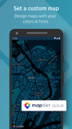
Choose from various basemaps like street and satellite. Preview on a mobile device the map you previously designed with own colors and fonts in MapTiler Cloud.
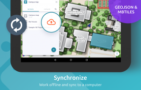
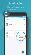
The app supports GeoJSON and MBTiles formats and data synchronization between multiple devices and desktop computer using cloud. I it easy to share the data with other people and collaborate! Perfect for mobile data collection for GIS and surveys.
Import scanned hiking maps, PDF maps, drone aerial imagery, nautical charts for sailing and navigation with a boat or a yacht, fishing maps, aeronautical charts for flight planning by pilots, parcels and city plans and other opendata from local government. OpenStreetMap vector maps are powered by OpenMapTiles project (the successor of OSM2VectorTiles). Maps can come from existing tile servers with OGC WMTS, TileJSON or XYZ tiles from.
Supported geodata formats by MapTiler: GeoTIFF, TIFF, JPEG, ECW, SID / MrSID, NOAA KAP / BSB, DEM, OziExplorer OZI OZF2 & OZFX3, WebP, JP2, JPEG2000, GeoJP2, Erdas, Grass, Safe, Sentinel2, SRTM, NASA imagery, USGS map sheets, exports from ESRI ArcGIS, ArcSDE, etc.
The GeoJSON can be converted from / to: ESRI ShapeFile (SHP), DXF, DWG, GPX, CSV and KML.
GPS konumunuzu kendi haritalarınızda görün. Haritalara noktalar, çokgenler ve çizgiler çizin. Bir konumla ilgili alan verilerini ve notları toplayın, bir fotoğraf ekleyin ve özel özellikleri doldurun.
MapTiler ile oluşturulan çevrimdışı haritaları görüntüleyin (https://www.maptiler.com).
Cadde ve uydu gibi çeşitli haritalardan birini seçin. Mobil cihazda daha önce MapTiler Cloud'da kendi renkleri ve yazı tipleri ile tasarladığınız haritayı önizleyin.
Uygulama, GeoJSON ve MBTiles formatlarını ve bulut kullanan birden fazla cihaz ve masaüstü bilgisayar arasında veri senkronizasyonunu destekler. Verileri diğer insanlarla paylaşmak ve işbirliği yapmak çok kolaydır! CBS ve anketler için mobil veri toplama için mükemmel.
Taranmış yürüyüş haritalarını, PDF haritalarını, hava görüntülerini, bir tekne veya yatla yelken ve deniz gezintisi için deniz haritaları, balık tutma haritaları, pilotlar, parseller ve şehir planları ve yerel yönetimlerden yapılan diğer açık verilere göre uçuş planlaması için hava çizelgeleri alın. OpenStreetMap vektör haritaları OpenMapTiles projesi (OSM2VectorTiles'ın halefi) tarafından desteklenmektedir. Haritalar mevcut fayans sunucularından OGC WMTS, TileJSON veya XYZ fayanslarından gelebilir.
MapTiler tarafından desteklenen coğrafi veri formatları: GeoTIFF, TIFF, JPEG, ECW, SID / MrSID, NOAA KAP / BSB, DEM, OziExplorer OZI OZF2 ve OZFX3, WebP, JP2, JPEG2000, GeoJP2, Erdas, Çimen, Güvenli, Sentinel2 görüntüleri, USGS harita sayfaları, ESRI ArcGIS, ArcSDE vb.
GeoJSON, / dan: ESRI ShapeFile (SHP), DXF, DWG, GPX, CSV ve KML'ye dönüştürülebilir.
MapTiler Mobile - Sürüm 2.0.1
(12-03-2020)MapTiler Mobile - APK Bilgisi
APK sürümü: 2.0.1Paket: com.maptiler.geoeditorMapTiler Mobile uygulamasının en son sürümü
Diğer sürümler


 4.33
4.33


Aynı kategorideki uygulamalar


Hoşuna gidebilecekler...


